New Delhi, July 27 (IANS) India's leading advanced digital maps provider MapmyIndia on Wednesday released the country's first and fully-indigenous 360-degree panoramic street view and 3D Metaverse Maps Service, as Google Maps returned to India with its 'Street View' offering after a decade. The service now is available on free mapping portal Mappls.com on the web for mobiles and desktops and the Mappls App on Android and iOS. With Mappls RealView, users can virtually explore India like never before and see and interact with full 360-degree panoramas of streets and roads looking out into various tourist, residential and commercial areas of cities and travel destinations as well as highways. "Users can also experience immersive 3D maps for pan India and detailed interactive 3D models of iconic tourist, commercial and residential landmarks across the country," said Rohan Verma, CEO and Executive Director, MapmyIndia. The service, combined with Mappls' detailed house-address level 2D maps from MapmyIndia and ISRO's rich catalogue of satellite imagery and Earth observation data which MapmyIndia has integrated, gives a full and immersive metaverse experience to users. "We are excited to give to users in India, a fully indigenous alternative to foreign map apps, that is more advanced in its capabilities and is more valuable for users, while also being fully Indian," said Verma. Mappls Review covers thousands of kilometres each in metropolitan areas and cities such as Greater Mumbai, Bengaluru, Delhi-NCR, Goa, Pune, Hyderabad, Chennai, Jaipur, Ahmedabad, Gandhinagar, Chandigarh, Jodhpur, Patna, Nashik, Aurangabad, Ajmer and more towns and highways connecting them. The entire Mappls RealView maps repository covers hundreds of thousands of kilometres, including more than 40 crore geo-tagged 360 degree panoramas, videos and panoramas which give exact ground reality, said the company. MapmyIndia has already made live a part of its repository - covering nearly 100,000 kms across hundreds of cities and highways for free for consumers. "Enterprises across the private and public sector as well as app developers, can access, integrate and leverage larger and more detailed RealView maps coverage as well as RealView technology-based APIs and solutions using data analytics, computer vision and AI for various use," the company noted. The company has served more than 2,000 enterprise customers since inception. It pioneered digital mapping in India in 1995.

MapmyIndia takes on Google with India's first 360-degree panoramic street view
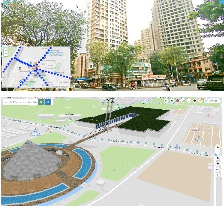
MapmyIndia takes on Google with India's first 360-degree panoramic street view. -- IANS